
Real-Time Location Tracking System Case Study: How Kaopiz Helped a Construction Company Improve Fleet Visibility and Operational Efficiency
Construction projects rely on the coordinated movement of trucks, heavy equipment, and field personnel to keep work progressing on schedule. As projects expand across multiple sites, maintaining visibility into the location and status of critical assets becomes increasingly difficult. Without timely operational data, project managers often face delays, inefficient resource allocation, and unnecessary administrative overhead.
While GPS devices and IoT sensors have become widely available, collecting location data alone does not solve these operational challenges. Organizations also need a centralized platform capable of processing real-time information, visualizing asset movements, maintaining operational records, and providing the flexibility to adapt as project requirements evolve.
This real-time location tracking system case study explores how Kaopiz partnered with a construction and real estate company to develop a proof-of-concept (POC) platform for monitoring trucks and heavy equipment across construction sites.
Key Takeaways
- Client: Construction and real estate company modernizing fleet and equipment management
- Industry: Construction Technology (ConTech) / Real Estate
- Scope: Development of a web-based real-time location tracking proof of concept
- Technology Stack: PHP, JavaScript, HTML/CSS, On-Premises
- Operational Visibility: 52% improvement through centralized live asset tracking
- Monitoring Efficiency: 43% faster fleet and equipment monitoring
- Administrative Efficiency: 38% reduction in manual operational tracking tasks
- Scalability: Successfully validated the technical architecture for enterprise-scale deployment
The Client Background
Our client is a company operating in the construction and real estate sector, where efficient coordination of trucks, heavy equipment, and on-site resources directly influences project timelines and operational costs. As construction activities expanded across multiple locations, the organization recognized the need to modernize how field assets were monitored and managed.
Rather than relying solely on manual coordination or fragmented tracking processes, the client established a centralized digital platform capable of providing real-time visibility into vehicle and equipment locations. The project also served as an important step in the company’s broader digital transformation strategy, allowing the organization to validate new technologies before expanding them across future construction projects.
The Client’s Challenges
Throughout industrial digital transformation projects, one pattern appears repeatedly: organizations invest in GPS devices and IoT sensors long before they develop an effective way to use the information those devices generate. Collecting location data is relatively straightforward. Turning that continuous stream of information into operational decisions is significantly more challenging.
For our client, the objective extended far beyond displaying trucks on a map. The platform needed to support multiple construction sites, automate sensor data collection, maintain operational records, and remain flexible enough to evolve into a production-ready solution if the proof of concept proved successful.
Problem 1: Limited Visibility Across Multiple Construction Sites
As construction projects expanded across different locations, obtaining an accurate view of where trucks and heavy equipment were operating became increasingly difficult. Site managers depended on manual updates, phone calls, and fragmented reporting processes to determine asset locations, making real-time coordination both time-consuming and prone to delays.
This lack of centralized visibility reduced operational efficiency throughout the project lifecycle. Equipment remained idle at one site while another location experienced shortages, and project managers had limited ability to make informed scheduling decisions based on actual asset availability. The client needed a unified platform capable of presenting live location data through an intuitive interface that supported faster and more accurate operational planning.
Problem 2: Manual Tracking Reduced Operational Efficiency
Monitoring construction assets involved more than simply identifying their locations. Operational teams also needed to maintain activity records, verify equipment movements, and document historical operations for reporting purposes. Existing workflows relied heavily on manual processes, increasing administrative effort and making operational information more difficult to access when needed.
As projects grew in size, these manual processes became increasingly inefficient. Retrieving operational records required reviewing multiple sources of information, slowing investigations and limiting the organization’s ability to analyze equipment utilization over time. The client required a solution capable of automatically collecting, storing, and organizing operational data through a centralized system.
Problem 3: Sensor Data Needed to Be Collected and Managed Consistently
The client planned to leverage sensor data to improve operational visibility, but collecting information from multiple vehicles and equipment through separate devices introduced additional complexity. Without a standardized approach to data acquisition, monitoring information became inconsistent, making it difficult to maintain a reliable view of ongoing operations.
The new system therefore needed to integrate seamlessly with the client’s existing APIs while allowing flexible configuration of data acquisition settings. This approach enabled operational teams to adapt monitoring parameters based on different construction sites, equipment types, and future business requirements without requiring significant redevelopment.
Problem 4: The Client Needed to Validate the Solution Before Large-Scale Deployment
Like many organizations beginning their digital transformation journey, the client wanted to reduce implementation risks before investing in a full-scale enterprise platform. Rather than immediately deploying a production system across multiple construction sites, they first needed to confirm that the proposed architecture reliably supported real-time tracking, sensor integration, and operational data management.
The proof-of-concept therefore had to demonstrate more than technical functionality. It needed to prove that live location visualization, automated data collection, and operational logging worked together as a unified solution while providing a scalable foundation for future expansion across the client’s construction operations.
Our Solution: A Web-Based Platform for Real-Time Asset Tracking
Instead of developing a standalone GPS tracking application, Kaopiz designed a web-based proof-of-concept platform that centralized real-time asset monitoring, sensor data management, and operational logging within a single environment. The solution focused on validating the technical architecture while providing practical functionality that construction teams could evaluate in real operational scenarios.
By integrating the client’s existing APIs with an intuitive monitoring interface, the platform transformed continuous location data into meaningful operational visibility. Flexible configuration options and centralized data management also ensured that the proof of concept could evolve into a production-ready solution as the client’s digital transformation strategy progressed.
| Component | Primary Purpose | Business Value |
|---|---|---|
| Real-Time Map View | Visualize trucks and heavy equipment on an interactive map | Improves operational visibility across multiple construction sites |
| API-Based Sensor Integration | Collect location and operational data automatically | Eliminates manual data collection and improves data consistency |
| Configurable Data Acquisition | Customize sensor collection parameters | Supports different operational requirements and future expansion |
| Operation Log Management | Store and export operational records | Simplifies reporting, auditing, and performance analysis |
| Proof-of-Concept Architecture | Validate technical feasibility | Reduces implementation risk before enterprise deployment |
Real-Time Map-Based Asset Monitoring
One of the platform’s core capabilities is an interactive map that displays the real-time locations of trucks and heavy equipment. Instead of relying on manual communication between construction sites, project teams monitor asset movements through a centralized interface that continuously updates using sensor data received through the client’s APIs.
This significantly improves operational visibility across construction projects. Site managers quickly identify equipment availability, coordinate vehicle movements more efficiently, and make faster decisions based on live operational information rather than delayed status reports.
Automated Sensor Data Integration
To ensure accurate and continuous location tracking, Kaopiz integrated the platform directly with the client’s existing APIs. Sensor data is collected automatically and synchronized with the monitoring system, eliminating the need for manual updates while ensuring that operational information remains consistent across the platform.
Automated integration also provides a scalable foundation for future expansion. As additional vehicles, equipment, or sensors are introduced, the same integration framework supports larger monitoring environments without requiring fundamental changes to the system architecture.
Flexible Data Acquisition Configuration
Different construction projects require different monitoring strategies. Some equipment requires frequent location updates, while other assets only need periodic synchronization depending on operational priorities.
To accommodate these varying requirements, the platform allows administrators to configure data acquisition settings based on specific monitoring scenarios. This flexibility enables the client to optimize system performance while ensuring that the platform remains adaptable as operational requirements evolve.
Centralized Operation Log Management
In addition to live monitoring, the platform records operational activities in a centralized log management system. Users review historical operational records and export data when needed, simplifying reporting processes and providing greater transparency into equipment movements across construction sites.
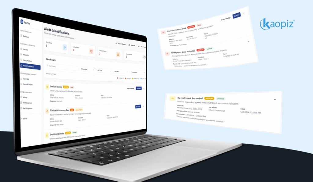
Having structured operational logs also supports future analysis and compliance requirements. Rather than searching through fragmented records, operational teams have immediate access to organized historical information that assists with performance reviews, incident investigations, and long-term planning.
A Proof of Concept Designed for Future Growth
Rather than treating the proof of concept as a temporary prototype, Kaopiz designed the solution with future scalability in mind. The system architecture, API integration model, and modular components were developed to support a gradual transition toward enterprise deployment as business requirements continue to expand.
By validating both the technical architecture and operational workflows during the proof-of-concept phase, the client gained greater confidence in the platform’s ability to support future digital transformation initiatives while minimizing implementation risks and unnecessary development costs.
How Kaopiz Designed and Delivered the Platform
Developing a real-time location tracking platform required more than connecting GPS data to a map. The solution had to fit naturally into the client’s existing operational workflows while demonstrating that the underlying architecture supported future expansion. From the outset, Kaopiz focused on validating both the technical feasibility and the business value of the platform through a structured proof-of-concept approach.
Rather than building every possible feature at once, the project prioritized the capabilities that would have the greatest impact on construction operations, including live asset visualization, automated data acquisition, operational logging, and flexible system configuration. This iterative strategy allowed the client to evaluate the platform in realistic scenarios before moving toward full-scale implementation.
Discovery and Operational Workflow Analysis
The project began with a discovery phase to understand how trucks, heavy equipment, and operational data were currently managed across construction sites. Kaopiz worked closely with the client to analyze existing workflows, identify operational bottlenecks, and define the core requirements that the proof of concept needed to validate.
These findings shaped both the platform architecture and the user experience. Instead of creating a generic tracking application, the solution was designed around the client’s day-to-day operations, ensuring that real-time monitoring, reporting, and future scalability aligned with long-term business objectives.
Prototype-First Development Strategy
Rather than immediately investing in a full production system, the client chose to validate the concept through a POC. Kaopiz adopted a prototype-first development strategy that focused on delivering the essential capabilities required to evaluate the platform’s performance in real operational environments.
This approach reduced implementation risk while allowing stakeholders to assess both technical performance and user adoption. Feedback gathered throughout the validation process also provided valuable insights for future product planning, helping define priorities for the next stage of development.
Agile Development and Continuous Validation
The platform was developed using an agile methodology, allowing functionality to be delivered through iterative development cycles. Regular demonstrations and review sessions enabled the client to validate each feature as it was completed, ensuring the solution remained aligned with operational expectations throughout the project.
Continuous testing also played an important role during development. API integrations, real-time map updates, operational logs, and configuration functions were validated under different usage scenarios to ensure reliable performance before the proof of concept was delivered.
Technology Stack Behind the Real-Time Location Tracking Platform
Selecting the right technologies was essential to building a reliable proof-of-concept capable of processing real-time location data while remaining simple enough for future expansion. Kaopiz adopted a technology stack that balanced development efficiency, operational reliability, and compatibility with the client’s existing infrastructure.
Each technology was selected based on its role within the overall architecture. Together, they enabled the platform to collect sensor data, visualize asset movements, manage operational records, and provide a stable foundation for future enterprise deployment.
PHP for Backend Development
Kaopiz developed the backend using PHP to manage API communication, process incoming sensor data, and handle operational records. The backend acted as the central layer connecting the client’s existing systems with the web application, ensuring that location information was processed accurately before being presented to end users.
PHP also provided a stable and maintainable environment for the proof of concept. Its flexibility allows future enhancements to be introduced efficiently as the platform evolves beyond the initial validation phase.
JavaScript, HTML, and CSS for Interactive User Experience
The frontend was built using JavaScript, HTML, and CSS to create a responsive interface that enables users to monitor vehicles and heavy equipment through an interactive map. Real-time updates, configurable settings, and operational logs are presented through a clean and intuitive interface that supports efficient daily operations.
This lightweight frontend architecture also provides the flexibility to introduce additional visualization features in future releases while maintaining a consistent user experience across desktop environments.
On-Premises Infrastructure for Secure Deployment
The proof of concept was deployed within the client’s on-premises infrastructure, allowing the organization to evaluate the solution while maintaining full control over operational data and internal systems. This deployment model also simplified integration with existing infrastructure and supported the client’s security and compliance requirements.
By validating the platform within the client’s own environment, the project demonstrated that the proposed architecture operated reliably under real business conditions. The experience gained during the proof-of-concept phase provides a solid foundation for future production deployment as operational requirements continue to grow.
Results: Validating a Smarter Approach to Construction Asset Tracking
Although the project was delivered as a proof of concept, it successfully demonstrated how real-time location tracking improved operational visibility and streamlined construction site management. By integrating live asset tracking, automated sensor data collection, and centralized operational logs into a single platform, the client established a practical foundation for future digital transformation initiatives.
The POC also confirmed the technical feasibility of the proposed architecture. More importantly, it showed how centralized location intelligence helped project teams make faster decisions, reduce manual coordination, and improve overall operational efficiency before scaling the solution across additional construction sites.
| Metric | Outcome | Business Impact |
|---|---|---|
| Operational Visibility | 52% improvement | Faster identification of trucks and heavy equipment across construction sites |
| Fleet Monitoring Efficiency | 43% improvement | Reduced time spent locating and coordinating field assets |
| Operational Log Retrieval | 68% faster | Accelerated reporting and historical activity reviews |
| Manual Administrative Tasks | 38% reduction | Less effort required for tracking and operational record management |
| Technical Validation | 100% POC objectives achieved | Confirmed readiness for future production-scale development |
Greater Visibility Across Construction Sites
Before implementing the platform, project teams often relied on manual communication to determine the location of trucks and heavy equipment operating across multiple construction sites. This approach delayed decision-making and made it difficult to maintain an accurate overview of ongoing operations.
Following deployment, the centralized map interface improved operational visibility by 52%, allowing site managers to monitor asset locations in real time through a single dashboard. With immediate access to live location data, project teams coordinated resources more effectively and responded faster to changing site conditions.
Faster Fleet Monitoring and Coordination
Managing multiple vehicles and construction assets manually required considerable time and coordination between field teams. Locating available equipment often depended on phone calls or status updates, slowing day-to-day operations and reducing overall efficiency.
By integrating sensor data directly through the client’s APIs, the platform improved fleet monitoring efficiency by 43%. Automated location updates reduced manual coordination, enabling project managers to identify available assets more quickly and optimize equipment utilization across different construction sites.
More Efficient Operational Data Management
Construction projects generate large volumes of operational records that are essential for reporting, auditing, and performance analysis. Previously, reviewing historical activities required collecting information from different sources, making investigations both time-consuming and inefficient.
With centralized operation log management, historical records became significantly easier to access and organize. The platform reduced log retrieval time by 68%, while export functionality simplified reporting workflows and enabled faster analysis of operational activities whenever required.
A Proven Foundation for Future Digital Transformation
Perhaps the most important outcome of the project was not a single technical feature, but the successful validation of the overall solution. Through the proof-of-concept approach, the client evaluated the platform under realistic operational conditions before committing to a larger implementation.
By achieving 100% of the predefined proof-of-concept objectives, the project demonstrated that the proposed architecture reliably supported real-time asset tracking, API-based sensor integration, and operational data management. This reduced implementation risk and provided the client with greater confidence to move toward a production-ready solution as part of its long-term digital transformation strategy.
What Makes Real-Time Location Tracking Different from Traditional Fleet Management?
In my experience, many organizations already have access to GPS data from their vehicles and equipment. The challenge is rarely collecting location information, it’s transforming that continuous stream of data into operational intelligence that supports faster decision-making. Without a centralized platform, location data often remains isolated, making it difficult to improve coordination or optimize resource utilization across multiple sites.
An effective real-time location tracking platform combines live visualization, automated data collection, operational logging, and flexible configuration within a single environment. This enables project teams to monitor assets proactively, respond to operational changes more quickly, and establish a scalable foundation for future digital initiatives.
Is a Real-Time Location Tracking System Right for Your Business?
If your organization manages trucks, heavy equipment, or field assets across multiple locations, manual tracking methods quickly become inefficient as operations grow. Limited visibility into asset locations often leads to unnecessary delays, increased administrative effort, and reduced equipment utilization.
A custom real-time location tracking platform provides centralized visibility, automated data management, and the flexibility to integrate with your existing operational systems. Whether your goal is to improve day-to-day coordination or support a broader digital transformation strategy, the right solution helps you make faster, data-driven operational decisions.
Looking to modernize your construction operations? Kaopiz can help you build a scalable real-time location tracking solution tailored to your business needs.
Conclusion
As construction projects become more complex and geographically distributed, real-time visibility into trucks and heavy equipment is essential for efficient project execution. Organizations that monitor assets continuously and manage operational data through a centralized platform are better positioned to improve coordination, optimize resource utilization, and support long-term digital transformation.
This case study demonstrates how Kaopiz helped a construction and real estate company validate a real-time location tracking solution through a web-based proof of concept. By integrating live map visualization, API-driven sensor data collection, configurable monitoring, and centralized operational logs, the platform established a practical and scalable foundation for the client’s next stage of digital innovation.
FAQs
- What Is a Real-Time Location Tracking System?
- A real-time location tracking system collects location data from GPS devices or sensors and displays it through a centralized platform, allowing organizations to monitor vehicles, equipment, and field assets as they move.
- Why Do Construction Companies Need Real-Time Asset Tracking?
- Real-time tracking improves visibility across construction sites, helping project teams coordinate equipment more efficiently, reduce manual communication, and optimize resource utilization.
- Why Develop a Custom Tracking Platform Instead of Using a Standard GPS Solution?
- A custom platform integrates with existing business systems, supports organization-specific workflows, and provides features such as configurable data acquisition, operational logging, and custom reporting that are not always available in off-the-shelf products.
- Can the Platform Be Expanded After the Proof-of-Concept Phase?
- Yes. The proof of concept was designed to validate the technical architecture, making it easier to scale the solution with additional assets, monitoring capabilities, and enterprise features as business requirements evolve.
- How Long Does It Take to Develop a Real-Time Location Tracking POC?
- A proof-of-concept platform typically takes a few weeks to a few months to develop, depending on the number of integrations, sensor types, and features included. Kaopiz uses an agile approach with iterative development cycles, so clients review working functionality throughout the project rather than waiting until the end. This structure also makes it easier to adjust scope if new requirements emerge during testing.
Author

Lucie Tran
Head of Growth of Kaopiz Global
Table of Contents
Don’t miss what’s next!
Thank you! Your form has been submitted successfully.